23 Days/22 Nights June to August Moderate
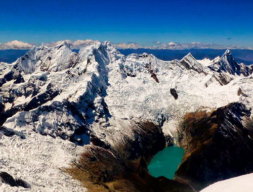
Highlights of the Cordillera Blanca. The highest tropical mountain range in the world, the Cordillera Blanca is part of the spectacular Andes that form the spine of South America. A mecca for hikers and outdoor enthusiasts, the region boasts over 50 peaks that exceed 15,000 feet, 700 glaciers and 300 lakes.
The Cordillera Huayhuash (Huayhuash Range): The Huayhuash Range is the second highest tropical mountain chain in the world, after the Cordillera Blanca (White Range), immediately to the north. Even though it is located 120 kilometers from the Pacific Ocean, the crest forms part of the Continental Divide of South America; the waters of the eastern slope flow to the Marañon River, a principal tributary of the Amazon.
Running from north to south, the main zone has some twenty summits within about 25 km, with a secondary mountain change of summits of lower elevation toward the west that is about 15 km long. Six of the peaks are higher than 6,000 meters. Among the peaks, Yerupajá (6,617 m) stands out - it is the second highest mountain in Peru (after Huascarán, at 6,768 m.) Also of note is Siula Grande (6,344 m), which achieved fame through the book and subsequent film “Tocando el Vacio“ (Touching the Void) by mountaineer Joe Simpson.
This area also hosts dozens of glacial lakes of incomparable beauty. The closest towns are Chiquián (3,400 m) and Cajatambo (3,375 m)
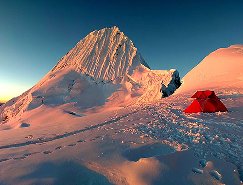
About Alpamayo Peak: The pyramid shaped Alpamayo is considered one of the most beautiful mountains in the world. The ascent toward the peak is very steep and the majority of it is a technical climb. This mountain should only be attempted by those who are well acclimatized and who have summited of other high peaks. From one side Alpamayo is an almost perfect pyramid, covered with enormous ice shelves. The other face, the trapezoidal southwest wall, is even more beautiful. All of the Cordillera Blanca mountain range is protected by Huascarán National Park, a paradise of snowcapped peaks. The park also includes the peaks of Huandoy and Huascarán (the highest mountain in Peru), as well as 663 glaciers, 269 lakes, some 42 rivers, as well as 33 archaeological sites.
Alpamayo: The Most Beautiful Mountain in the World: Alpamayo, proclaimed “The Most Beautiful Mountain in the World” by Alpinismus magazine in 1966, rises to an elevation of 19,511 feet in the Huascarán National Park in the province of Huaylas (Ancash).
The snow-covered Alpamayo in the Cordillera Blanca range of the Andes Mountains has an unmistakable pyramidal shape, an attractive feature for visitors who come to scale its summit.
Location in the Huascarán National Park
Alpamayo is one of the highest summits in Huascarán National Park (eight-day ascent). The peak, on the northern end of the Cordillera Blanca's western branch, can be accessed from the city of Caraz (290 miles from Lima), at the northern end of Callejón de Huaylas. The approach passes through Cashapampa and the Santa Cruz gorge to the Quisuarpampa area, where it then climbs to the Arhuaycocha gorge and reaches base camp at 14,100 feet above sea level.
Mountaineering / Trekking
For those who love mountaineering and trekking, Alpamayo's difficulty level ranges from intermediate to hard depending on the time of year or weather conditions. The recommended time for visiting Alpamayo is from May through September.
There are at least 13 ways to access Alpamayo, so it is important to be informed and go with a specialized group with the skills and knowledge to reach the summit safely. There are packaged trips for both rock climbing or trekking that include a day of acclimatization and a chance to see the different tourist attractions around Alpamayo.
It is important to remember that temperatures on Alpamayo are very low and can drop to 21°F at night and average 50°F during the day, with dry weather conditions and icy cold.
About Nevado Alpamayo Routes: Alpamayo should not be underestimated. Lessthan half of the climbers coming to the BC make it to the top.
NB: After the July-2003-icefall the conditions in Alapmayo SW-face seem to have changed.
Ferrari: AD+, 10m 70°, 8 pitches 45°, 1 pitch 55°. 5-7h.
Frech Direct: D+ 50°-65°, 10 pitches. 6-8h Start near the lowermost part of the bergschrund (1½h). After 1/3 of the ascent follow the runnel leading to the top.
North Ridge: D The route of the first ascent. Nowadays unusual due to the higher objective risks. The ridge can be gained from Laguna Jancarurish or by traversing from the col.
Descent: Rappel down the way you came respectively the Ferrari Route (snow stakes most times in situ).
Day 1: Flight from Europe to Lima. Overnight in the hotel
Day 2: Travel by bus to Huaraz (3100m). The trip is 400km and takes 8 hours
Day 3: Day 1: Huaraz (3100 m) - Public transport to Puente Santa Cruz - Trekking Hike Cordillera Negra to Laguna Wilcacocha (3725 m) - Return to Huaraz
Day 4: Huaraz - Transfer Cordillera Huayhuash - Camp Matacancha (4150 m)
Day 5: Matacancha - Trekking to Cacanampunta (4700 m) - Laguna Mitococha (4300 m)
Day 6: Mitucocha - Trekking to Punta Carhuac Pass (4640 m) - Laguna Carhuacocha (4200 m)
Day 7: Carhuacocha - Trekking to Siula Pass (4950 m) / Laguna Quesillococha – Huayhuash (4450 m)
Day 8: Huayhuash - Trekking to the village of Portachuelo de Huayhuash – Laguna Viconga / Hot Springs (4400 m)
Day 9: Laguna Viconga - Trekking to Punta Cuyoc Pass (5020 m) - Huanacpatay (4350 m)
Day 10: Huanacpatay - Trekking to Village of Huayllapa (3600 m) - Huatiac (4290 m)
Day 11: Huatiac - Trekking to Punta Tapush (4800 m) - Cashpapampa (4500 m)
Day 12: Cashgapampa - Trekking to Llaucha Pass (4750 m) - Laguna Jahuacocha (4066 m), Optional: Climb Diablo Mudo (5350 m)
Day 13: Jahuacocha - Trekking to Jahuapunta Pass (4650 m) - Village of Pocpa (3600 m); Transfer to Huaraz
Day 14: Rest Day in Huaraz - Optional: Rock climbing at the walls of Chancos
Day 15: Huaraz - Transfer drive about 3 Hours to village Cashapampa; meeting team and burros, trekking up to Llamacoral (3850 m)
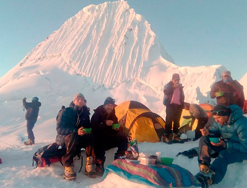
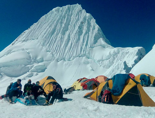
Day 16: Llamacoral - Trekking to Base Camp of Alpamayo (4350 m)
Day 17: Alpamayo Base Camp - Ascend to Alpamayo Moraine Camp (4900 m)
Day 18: Moraine Camp - Ascend to Alpamayo High Camp (5300 m)
Day 19: High Camp - Ascend to Alpamayo Summit (5947 m) - High Camp (5300 m) or Descend to Base Camp (4300 m)
Day 20: Base Camp - Descent through Quebrada Santa Cruz - Cashapampa - Transfer to Huaraz
Day 21: Transfer to the Anta Airport and 50 minute flight to Lima, or transfer to the bus terminal for the 8 hour ride to Lima. Transfer to the hotel
Day 22: Stay in Lima - Transfer to the Airport
Day 23: Arrival in Europe or the country of origin
Day 1: Flight from Europe to Lima. Overnight in the hotel
Arrival in Lima - a large city with a population of approximately 11 million - the largest city in South America. Rest. If you wish, explore the city on your own. Overnight Hotel (-/-/-)
Day 2: Travel by bus to Huaraz (3100m). The trip is 400km and takes 8 hours
This will be a varied and interesting voyage First we go to the Pan American highway toward the north, across the impressive Pacific coastal desert. We continue toward the high terrain and at Conococha Pass (4020 m) we pass through the Cordillera Negra into the Santa Valley to Huaraz (3100m.) Once we cross the pass, you’ll see the charming view of the mountains of the Cordillera Blanca, without a doubt some of the most impressive scenery in the world. You can also fly via LCPERU - flight duration 50 minutes. Overnight Hotel (B/-/-)
Day 3: Day 1: Huaraz (3100 m) - Public transport to Puente Santa Cruz - Trekking Hike Cordillera Negra to Laguna Wilcacocha (3725 m) - Return to Huaraz
From Huaraz our guide will pick up you at 8.00. After walking to the Market central where you will get the Public transport to go until Puente Santa Cruz (Chihuipampa bridge), 7 kilometers from the city of Huaraz. From this point begins our ascent in a zig-zag towards Willcacocha, walk about 2 and ½ hours approximately. Arriving observe the scenic beauty of the lagoon surrounded by cattails plants, bunch grass and queñual, also we see wild ducks, aquatic animals, species of birds (eagle, hawk). This area is a natural viewpoint of the Cordillera Blanca, we will have panoramic views of the snowy: Nevado Huascaran, Nevado Chopicalqui, Nevado Hualcán, Nevado Copa, Nevado Vallunaraju, Nevado Ocshapalca, Nevado Ranrapalca, Nevado Palcaraju, Nevado Churup. We will stay one hour to visit the lagoon, enjoy the scenery, take pictures, an easy hike about 3 hours with great views of nature, after enjoy our day return to Huaraz. Overnight Hotel (B/L/-)
Day 4: Huaraz - Transfer Cordillera Huayhuash - Camp Matacancha (4150 m)
Transfer in van via the Santa Valley across the Pachacoto Bridge, then continue on the mountain road in Puja Raimondi National Park (4780 m) to Huarapasca Pass. Along this road we see giant plants in the form of a candle which flourish only in the south of the Cordillera Blanca. At the top of the pass, you’ll see the Pasto Ruri glacier. Continuing over 2 more passes to the village of Matacancha (4150 m) in the Huayhuash region, the starting point of the trekking circuit. Meet with the team of guides, the mule drivers (and their burros) and first camp. Overnight Camp (B/L/D)
Day 5: Matacancha - Trekking to Cacanampunta (4700 m) - Laguna Mitococha (4300 m)
First day of trekking: Climb the steep slope of Matacancha to Cacanampunta Pass (4700 m), which forms the continental divide between the Pacific and Atlantic Oceans, and the spectacular open views of the wild mountains of Huayhuash, in particular the peaks of Rondoy and Jirishanca. Descent over wide fields and a beautiful camp at Laguna Mitococha (4300 m). Overnight Camp (B/L/D)
Day 6: Mitucocha - Trekking to Punta Carhuac Pass (4640 m) - Laguna Carhuacocha (4200 m)
An inviting climb to Punta Carhuac Pass (4,650 m) and descent over smooth rolling grasslands to Carhuacocha Lake (4,200 m), one of the best campsites on the route. If there is no wind, we’ll see the peaks of rock and ice (Jirishancas and Yerupajá Grande y Chico) reflected on the surface of the calm waters. At the lake live indigenous farmers - with their permission we may get to catch fresh trout for dinner! Overnight Camp (B/L/D)
Day 7: Carhuacocha - Trekking to Siula Pass (4950 m) / Laguna Quesillococha – Huayhuash (4450 m)
This part of the route is strenuous and has no obvious road. It passes through remote peaks and glaciers of Huayhuash, with the most magnificent panoramic view of the excursion. We pass Lake Carhuacocha and beyond that is the ice fall and retreating glacier of Sarapo Peak (6127m). We cross Siula Pass (4,950 m) with overwhelming panoramic views. The descent into camp at Quesillococha Camp (4,450 m), close to the small village of Carnicero, seems effortless after the climb. Alternative: If you prefer an easier day, there is a route that is a little longer but less demanding and less steep: flat along the east edge of Lake Carhuacocha, climb through the Quebrada Acoshpado to the summit of Carnicero Point (4,580 m) and the smooth descent to the two lakes of Atocshaiko to Carnicero Camp or Camp Huayhuash at Quesillococha Lake (4.450 m). Overnight Camp (B/L/D)
Day 8: Huayhuash - Trekking to the village of Portachuelo de Huayhuash – Laguna Viconga / Hot Springs (4400 m)
A wide commercial route extends to the south to the small village Portachuelo de Huayhuash, then to the headwaters of the Huayhuash River - the very green Suirococha Lakes (4,500 m.) The climb to the south extends past Portachuelo de Huayhuash (4,795 m) again dominated by impressive mountain panoramas, this time the ice covered peaks of the southern Huayhuash Range. Descend to the largest lake, and the southernmost point of the trek - Lake Viconga (4,400 m), one of the many water reservoirs for Lima. Viconga Hot Springs Camp (4,400 m). Overnight Camp (B/L/D)
Day 9: Laguna Viconga - Trekking to Punta Cuyoc Pass (5020 m) - Huanacpatay (4350 m)
Today is the highest pass of the Huayhuash Trek over Punto Cuyoc (5, 020 m). From the lake of Puscanturpa Gorge, we scramble over rocks and sand to the pass. The spectacular view is of the Raura Range to the east. The Puscanturpa Peaks loom very close along with the “giants” of Huayhuash, Sarapo, Siula and Yerupajá. We drop sharply to Huanacpatay Gorge and camp in fields close to the houses of Huanacpatay (4,350 m). Overnight Camp (B/L/D)
Day 10: Huanacpatay - Trekking to Village of Huayllapa (3600 m) - Huatiac (4290 m)
We hike along the river to the Calinca Valley (Rio Huayllapa) and continue to the village of Huayllapa (3,600 m). In the relatively low elevation, the trail takes us through dense vegetation with many colors of flowers - especially the shrubs called huishllac, named for their yellow color and open purple flowers, one of the sacred flowers of the Incas. We then have steep 3-hour climb to the north to camp in Huatiac (4,290 m). Overnight Camp (B/L/D)
Day 11: Huatiac - Trekking to Punta Tapush (4800 m) - Cashpapampa (4500 m)
At times the climb is steep and strenuous, under the steep glaciated cliffs of the high massif of Raju Collota to Punta Tapush Pass. Once again, magnificent views, including Nevado Diablo Mudo (Silent Devil) (5,350 m), tomorrow’s destination for the ambitious and physically strong climbers among us. Short descent from the pass north to Susococha Lake (4,600 m) and a little farther to Cashgapampa Camp (4,500 m). Overnight Camp (B/L/D)
Day 12: Cashgapampa - Trekking to Llaucha Pass (4750 m) - Laguna Jahuacocha (4066 m), Optional: Climb Diablo Mudo (5350 m)
Those climbing Diablo Mudo (5,223 m) begin very early and will have a long day. From the north side on the last steepest slopes, some with “penitentes“, we’ll use crampons, ice axe and harness. The feeling of success at reaching 5000 meters, and awesome views in the true sense of the word, Diablo Mudo is a well-deserved reward for the effort. The huge wild mountains of Huayhuash are laid out in front of you. Descent to the camp still follows the long route to Jahuacocha Lake. Option: Trekking without climbing Diablo Mudo. Short descent from Cashgapampa, turning into Angocancha Gorge (4,350 m) and ascent to Yaucha Pass (4,750 m), where we again stop and enjoy the impressive view. Steep descent toward the northeast in Huacrish Gorge (4,066 m), leading to Jahuacocha Lake (4,066 m). Camp on the edge of the lake, with a view dominated by Rondoy, Jirishanca and Yerupajá. Overnight Camp (B/L/D)
Day 13: Jahuacocha - Trekking to Jahuapunta Pass (4650 m) - Village of Pocpa (3600 m); Transfer to Huaraz
Last day of this trek. Climb the last pass - Jahua Punta - and a long descent to the camp in the village of Pocpa. In this village we finish our great adventure filled with so many experiences. Here we leave our team of mule drivers and burros. Our private transport is waiting to return to the capital of Andes mountaineering, Huaraz. Overnight Camp (B/L/-)
Day 14: Rest Day in Huaraz - Optional: Rock climbing at the walls of Chancos
Relaxing day in Huaraz. Optional: A classic location for many who like to practice rock climbing. This area is 40 minutes north of Huaraz. It was developed thanks to the guides of Don Bosco in the Andes in 1997. It has 8 developed routes of different difficulties. This is a good place to spend a quiet day in nature and at the end visit the hot springs to relax aching muscles. Overnight Camp (B/-/-)
Day 15: Huaraz - Transfer drive about 3 Hours to village Cashapampa; meeting team and burros, trekking up to Llamacoral (3850 m)
Huaraz Privat transfer drive about 3 Hours to village Cashapampa via valley of Santa river crossing villages Caraz, Yugay and Caraz; Starting the Trekking Santa Cruz; meeting team and burros, trekking up to Llamacoral (3850 m). Overnight Camp (-/L/D)
Day 16: Llamacoral - Trekking to Base Camp of Alpamayo (4350 m)
Camp Llamacoral - Trekking to Arhuaycocha (4300 m). With views of the peaks Alpamayo, Artesnorahu and Taulliraju. Night at the Base Camp of Alpamayo (4350 m). Overnight Camp (B/L/D)
Day 17: Alpamayo Base Camp - Ascend to Alpamayo Moraine Camp (4900 m)
Today we have a good breakfast and prepare the expedition equipment for Alpamayo, from here we begin using a local team (porters, cook and local guides), who will help us carry everything. We set out for the moraine after a small lunch in Base Camp. The trail takes us across the steep moraine at the tongue of the glacier to Moraine Camp (4,900 m).Overnight Camp (B/L/D)
Day 18: Moraine Camp - Ascend to Alpamayo High Camp (5300 m)
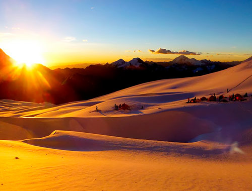
Alpamayo High Camp is on the steep glacier at the base of Alpamayo and Quitaraju. Due to the constant shrinkage of the glacier, every year we find a different situation along this section. We find magnificent views from High Camp the summit looks close enough to touch! We have dinner a bit early because we must rise very early, for the long day that awaits us tomorrow. High Camp (5,300 m). Overnight Camp (B/L/D)
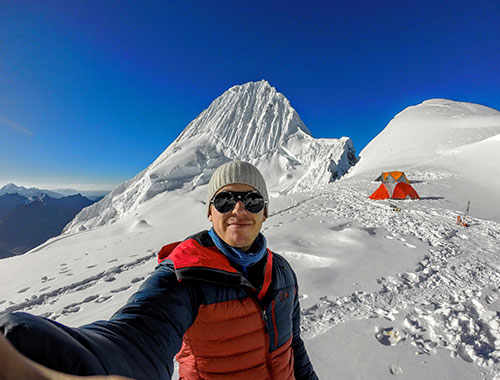
Day 19: High Camp - Ascend to Alpamayo Summit (5947 m) - High Camp (5300 m) or Descend to Base Camp (4300 m)
Summit day! One possible route is the French route, a 60 to 80 degree wall of ice which narrows toward the top. . Above the wall, you need to conquer a few meters to the highest point of the narrow ridge. At the summit, you will be rewarded with a magnificent view of the Cordillera Blanca! The neighboring peak of Quitaraju (6,036 m) is almost within striking distance; and to the southwest you can see the remarkable summit of Huascarán (6,768 m.) After a brief rest and photos at the summit, we return quickly to High Camp via a rappel down the route we came up. In good weather, the climb to the summit and return to base camp can be done before noon. The ascent takes 5-6 hours, while the descent takes about 2-3 hours. If participants are tired, we can stay one more night in High Camp. If everyone feels fine, which is usual, we descend to Alpamayo Base Camp (4,300 m). Overnight Camp (B/L/D)
Day 20: Base Camp - Descent through Quebrada Santa Cruz - Cashapampa - Transfer to Huaraz
Today we rise early in order to begin our hike, descending through the Santa Cruz valley to Cashapampa (about 6 hours.) In this village our minibus awaits to take us and the local expedition team back to Huaraz. Lodging at the hotel.Overnight Hotel (B/L/-)
Day 21: Transfer to the Anta Airport and 50 minute flight to Lima, or transfer to the bus terminal for the 8 hour ride to Lima. Transfer to the hotel
Options: Flight or bus. Flights are via LC-Peru and last 50 minutes. Overnight Hotel (B/-/-)
Day 22: Stay in Lima - Transfer to the Airport
Arrival in USA or Austria, Switzerland,Germany, etc. Overnight flight (B/-/-)
Day 23: Arrival in Europe or the country of origin
Arrival in USA or Austria, Switzerland,Germany, etc. Overnight Home (-/-/-)
Included meals: B=breakfast; L=lunch; D=dinner
Season: June to August
Difficulty: Moderate
Book Now
Travel packages, tours Archeology, Moche, Chiclayo, Trujillo, archeology, hiking beaches, sand, Chachan, Sipan, Tucume, Huaca Sol, Huaca Luna, Huaca el Brujo

Excursion to the heart of the Peruvian Jungle - Iquitos (106 m) - Tucan Expedition, enjoy an unforgettable trip
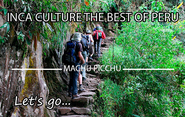
Trekking Inca Trail to Machu Picchu (Huayna Picchu 2.667 m)
 English
 Español
 Français
 Portugués
 Deutsch